Hancock County, Indiana: A Complete Guide to the Towns, History, and Hidden Corners
2026-04-14
Hancock County sits immediately east of Indianapolis — close enough to be a commuter corridor, far enough to still feel like small-town Indiana. It covers about 307 square miles, is home to roughly 80,000 people (2020 U.S. Census), and was named for John Hancock, the first signer of the Declaration of Independence. The county was established in 1828.
This guide walks through what the county is, the towns that make it up, and what’s worth knowing about each one — whether you live here, you’re driving through, or you’re moving to the Indy metro and trying to figure out which small town fits.
The basics
County seat: Greenfield Population: ~80,000 (2020 Census) Founded: 1828 Area: 307 square miles Named for: John Hancock Adjacent counties: Marion (west), Hamilton (northwest), Madison (north), Henry (east), Rush (southeast), Shelby (south)
Hancock is bisected east-to-west by two historic routes: Interstate 70 and U.S. 40 — the Historic National Road. The National Road was the first federally funded interstate in American history, completed through Indiana in the 1830s, and U.S. 40 still follows its original alignment through the county. Most of Hancock’s older towns grew up along that road.
State Road 9 and State Road 234 are the other main arteries — you’ll hit SR-9 running north-south through Greenfield, and SR-234 through Fortville.
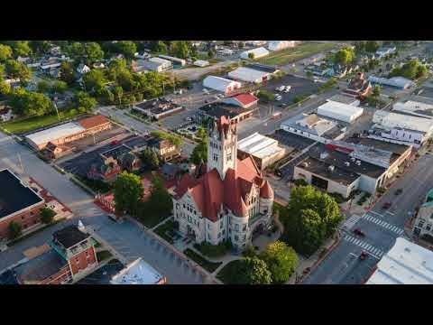
Greenfield — the county seat
ZIP: 46140 Role: County seat, largest town in Hancock County
Greenfield is the civic and historical center of the county. Courthouse, county offices, the main hospital — they’re all here. It’s also the birthplace of James Whitcomb Riley, “the Hoosier Poet,” born in Greenfield on October 7, 1849. Riley’s boyhood home on West Main Street is preserved as a museum, and the annual Riley Festival each October draws tens of thousands of visitors downtown. The festival has been running since 1911 and is one of the oldest continuously held community festivals in Indiana.
Downtown Greenfield still follows the old National Road alignment. Old brick storefronts, historic churches, and a small but active main-street commerce district. Greenfield Town Guide is the network site coming online next — it’ll cover the restaurants, services, and events here in depth.
New Palestine — the Dragons, the downtown, the festivals
ZIP: 46163 Guide: New Palestine Guide
Named after the town of New Palestine in Pennsylvania (which was named after the historical region), New Pal sits in the southwest corner of the county. It’s part of the Mt. Vernon Community School Corporation, which covers Fortville, McCordsville, and New Palestine.
Mt. Vernon’s football program, which represents all three towns, has won five state championships (2014, 2018, 2019, 2024, 2025) — all undefeated seasons. The program, under head coach Kyle Ralph, is one of the most dominant in modern Indiana high school football history.
New Palestine isn’t a browsable Main Street town the way Fortville is — the downtown core is compact and spread out, so you drive to the places you want to visit rather than strolling between them. Where New Pal shines is in its institutions: Frosty Boy Drive-In (an institution since 1976), Tony D’s, the Lions Club festivals, and a community that shows up for its annual events. The full directory, including 150+ local businesses, is on the New Palestine Guide.
Fortville — Main Street and the Pink Elephant
ZIP: 46040 Guide: Fortville Guide
Fortville is in the northwest corner of the county, bordering Hamilton County. Population is around 5,000 — small by metro standards, but the town has an outsized downtown. Main Street is anchored by Taxman Brewing, a Belgian-style craft brewery opened in 2017 that has won Great American Beer Festival medals. Alongside Taxman you’ll find FoxGardin Kitchen & Ale (New American, James Beard-recognized chef), Cortona’s Italian, Denver’s Garage (pizza in a preserved 1956 Phillips 66 service station), and a run of independent shops — Black Sheep Gifts, The Field, PJ’s Pink Boutique, Maduro on Main, and others.
Just east of town on State Road 238 sits the Pink Elephant — a roadside concrete pink elephant that has become a regional landmark and photo stop. Landmark Park on Vitality Drive hosts the Thursday Fortville Farmers Market (season opens late April) and serves as the venue for larger community events. Memorial Park on the south side of town handles youth sports and family events.
Fortville also shares the Mt. Vernon school district with New Palestine and McCordsville.
McCordsville — the fast-growing one
ZIP: 46055
McCordsville is the youngest and fastest-growing town in the county. Positioned along State Road 67 and near the county’s border with Hamilton, it’s seen significant residential development over the past two decades. The town is part of the Mt. Vernon school district alongside Fortville and New Palestine — all three towns feed into Mt. Vernon High School. McCordsville Guide is planned for the network but isn’t live yet.
Cumberland — the split town
Cumberland sits directly on U.S. 40 and is unique in that it straddles the Hancock-Marion county line — most of the town is in Hancock, but a portion extends into Indianapolis. It’s one of the oldest settlements along the National Road, founded in the 1830s as a stagecoach stop. Today it’s a small, quiet community and an easy stop if you’re driving the old National Road east out of Indy.
The smaller communities
Hancock also includes several smaller unincorporated towns and communities worth knowing:
- Wilkinson (ZIP 46186) — a small town in the east-central part of the county, notable for its grain elevator and rural character.
- Shirley (ZIP 47384) — partially in Hancock, partially in Henry County, along the north-east corner.
- Mohawk, Eden, Maxwell, and Warrington — unincorporated crossroads communities scattered through the county’s rural sections.
These places don’t have directories of their own (yet), but they’re part of the fabric of the county — rural, quiet, and rooted in the farms that still cover most of Hancock’s land area.
Geography and getting around
Most of Hancock County is flat, fertile farmland — corn and soybeans dominate. The county drains primarily into Sugar Creek and Brandywine Creek, both flowing generally southwest toward the White River system. There are no major lakes, but several creeks and smaller tributaries cut through the landscape.
Driving the county:
- I-70 is the fastest east-west route — use it to cross the county quickly
- U.S. 40 (Historic National Road) parallels I-70 and connects Cumberland → Greenfield → the eastern edge. Slower, prettier, more history
- SR-9 is your north-south spine, hitting Greenfield directly
- SR-67 runs diagonally northeast from Indianapolis through McCordsville
- SR-234 connects Fortville to Pendleton and points east
From downtown Indianapolis, Greenfield is about 25 minutes via I-70, Fortville is about 30 minutes via I-69 and SR-238, and New Palestine is about 20 minutes via U.S. 52.
What makes Hancock distinct
A few things set this county apart from the other doughnut counties around Indianapolis:
-
Historic National Road heritage. Unlike the Hamilton County growth corridor (Carmel, Fishers) which grew up around postwar highways, Hancock grew up around U.S. 40. The old Road towns — Greenfield, Cumberland — still show that lineage.
-
Three school districts, distinct identities. Mt. Vernon (Fortville/McCordsville/New Palestine), Greenfield-Central (Greenfield), and Eastern Hancock (Charlottesville/Wilkinson/Shirley area). Each district has its own culture, its own rivalries, and its own traffic on Friday nights.
-
Rural with proximity. You can be in downtown Indy in 25 minutes from most of the county, but you can also drive three miles from any town center and be surrounded by corn.
-
The literary connection. James Whitcomb Riley’s legacy is real and ongoing. The Riley Festival, the Riley Home, and the references woven through Greenfield’s identity give the county seat a distinct cultural anchor.
The guides in our network
- New Palestine Guide — restaurants, events, Mt. Vernon Dragons sports, and 150+ local businesses
- Fortville Guide — Main Street dining, Pink Elephant, Landmark Park, and the shops and services of downtown Fortville
- Greenfield Town Guide — coming next; Riley Festival, downtown Greenfield, and the county seat
- McCordsville Guide — planned
Each guide is independent, curated, and focused on one town — because the best way to know a place is through the people who actually live there.
If you’re new to the area, consider this the overview. If you’ve lived here your whole life, we’d love to hear what we should add. Get in touch or check out the town guides in the network.
Related Posts
Hancock County Farmers Markets: 2026 Season Guide
Every farmers market in Hancock County, Indiana for the 2026 season — Fortville Thursdays at Landmark Park, New Palestin...
Where to Eat in Hancock County: A Town-by-Town Guide
A practical town-by-town guide to eating in Hancock County, Indiana — breakfast, lunch, dinner, drinks, and dessert in F...